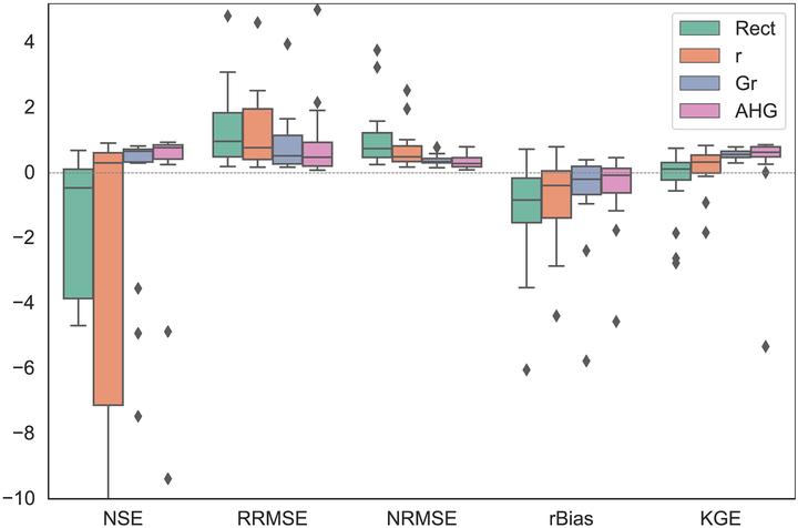
Abstract
The Surface Water Ocean Topography (SWOT) satellite mission expected to launch in 2021 will offer a unique opportunity to map river discharge at an unprecedented spatial resolution globally from its observations of water surface elevation, width and slope. Since river discharge will not be directly observed from SWOT, a number of algorithms have been developed with varying complexity to estimate discharge from SWOT observables. Outstanding issues include the lack of accurate prior information and parameter equifinality. We developed a new data assimilation discharge algorithm that aimed to overcome these limitations by integrating a data-driven approach to estimate priors with a model informed by hydraulic geometry relations. A comprehensive synthetic dataset of 18 rivers was used to evaluate the algorithm and four different configurations (rectangular channel, generic channel, and geomorphologically classified channel with and without regularization) aiming at evaluating the impact of progressively adding hydraulic geometry constraints to the estimation problem. The algorithm with the full set of constraints outperformed the other configurations with median Nash-Sutcliffe coefficients of 0.77 compared with -0.46, 0.31 and 0.66 while other error metrics showed identical performance. Results from this study show the promise of this hybrid data-driven approach at estimating river discharge from SWOT observations although a number of enhancements need to be tested to improve the operational applicability of the algorithm.