A Data Assimilation Framework for Generating Space‐Time Continuous Daily SWOT River Discharge Data Products
Abstract
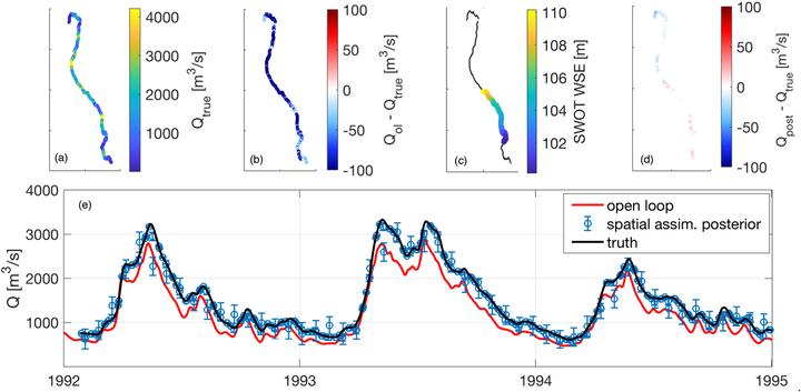
The Surface Water and Ocean Topography (SWOT) satellite will provide global observations of surface water storage and river discharge at an unprecedented high resolution and accuracy after its scheduled launch in 2021, but a limitation of SWOT observations is their spatial and temporal discontinuity associated with the SWOT orbital characteristics. Here, we describe a prototype data assimilation framework to assimilate synthetic SWOT water surface elevation observations into the LISFLOOD‐FP hydrodynamic model to generate a spatially and temporally continuous SWOT discharge data product. We develop the assimilation system with realistic errors in both the SWOT observations and model predictions. During a 3‐year period (consistent with the designed SWOT mission life), the assimilation effectively fills the observation gaps in both time and space across the 5,094‐km Upper Mississippi river network, where SWOT observations provide an average spatial sampling coverage of 55%. The assimilation results in a posterior discharge estimate agree well with the synthetic truth and better capture the peak flows in the significant 1993 flooding in this region; the daily posterior discharge estimates collectively increase the accuracy of the open‐loop (model‐only) discharge estimate by 41%. The posterior estimates show the largest improvement in areas where SWOT has higher sampling frequency and spatial sampling density and where the river has larger volumetric water storage. The accuracy improvement from the assimilation of SWOT data persists well between subsequent observations. Correcting the effects of bathymetric errors on hydrodynamic modeling prior to the assimilation is critical for the assimilation to improve discharge estimates.