The Utility of Infrequent Snow Depth Images for Deriving Continuous Space‐Time Estimates of Seasonal Snow Water Equivalent
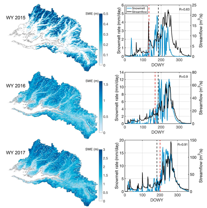 (Left column) Maps of estimated posterior snow water equivalent (SWE)fields (in meters) for each water year(WY) on basin‐averaged day‐of‐peak SWE; (right column) posterior basin‐average snowmelt time series compared tostreamflow at watershed outlet (correlation between snowmelt and streamflow is shown in upper right corner of eachpanel). The snow depth data assimilation day and the day‐of‐peak SWE are shown with vertical dashed black and redlines, respectively. DOWY = day of water year.
Abstract
Snow water equivalent (SWE), particularly in mountains regions, has been an elusive hydrologic measurement. We examine the utility of a data assimilation approach to generate space‐time continuous estimates of SWE from more readily available snow depth (SD) measurements. A multitemporal lidar data set provides a unique opportunity to assimilate single SD images and verify posterior estimates against SD images at nonassimilation times. Application over three water years shows significant improvement in the posterior estimates with an average correlation between estimated and measured SD fields of 0.88 compared to 0.52 for prior estimates that do not benefit from the assimilated SD data. We also show that posterior estimates are consistent with independent in situ SWE and streamflow measurements. This work demonstrates that using high‐resolution/high‐accuracy, but infrequent, SD measurements combined with a data assimilation framework could make significant inroads toward the goal of spatially distributed SWE and snowmelt estimates at the global scale.